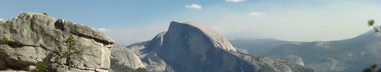
Schmuck 1 taking in the view from Dewey Point, Yosemite National Park.
The last time we did the hike from Glacier Point Road to Dewey Point, the trail was covered in six feet of snow and the valley was socked in with clouds (as described in our forthcoming book, “The Road to Whitney”). On that cold winter’s day when WE broke the trail to Dewey in our snowshoes, we rewarded only with a hot lunch and more than few cross-country skiers trying to steal our thunder (also recounted in the book). Saturday, November 10, 2018 was an entirely different story….
We hit the McGurk Meadow trailhead on Glacier Point Road at about 8:40 am on Saturday. It was a crisp 29 degrees when the Two Schmucks and a guest hiker, Ron D., set our Dewey. The sun was shining and there was very little breeze. In other words, a perfect day for a hike in Yosemite. But, you know what they say, a miserable hike in Yosemite beats a good day at work! But, there was nothing miserable about this hike. It was great weather and even better conversation for four miles when we broke out of the trees and were rewarded with sweeping views of the valley from 3,300 feet. A thin layer of clouds lazed around the granite peaks adding to the serenity and beauty of the views. El Capitan stood sentry across the gorge and the Merced River sparkled on the valley floor as it made it way through the canyon. The three of us stood in silence, in awe of what we saw before us. After a few moments, we scrambled around the natural stone platform to see the views from different perspectives. It was like opening presents on Christmas morning as each perch offered something a little different from the one before. We felt privileged to experience the park this way, a sight we did not get to see on that wintry day so many years ago….a sight that many people do not see just by going to the gift shop in the valley. For us, the only way to really experience Yosemite is in a pair of good, trail-rated hiking boots (Remember Rule 1!).
Trail Rating: 2
We talked a lot about our trail rating system to help guide other schmucks, noobs, and the otherwise unfamiliar about the nuances of experiencing our national parks. The scale goes like this: 1 is strolling about Fresno’s River Park Mall and 10 would be grinding it out up Yosemite Falls with a full backpack and a damn bear canister. The 8-mile round trip from Glacier Point Road to Dewey Point and back is a solid 2.
From the road, the well-traveled trail descends through cool pines before breaking out into McGurk Meadow in all its golden glory. A wooden footbridge get you over a creek, which was frozen when we crossed it, and the trail skates along the meadow until a peaceful forest of tall pines and sequoias swallows you up again. You will also hit a couple of junctions that marks the trails and mileage to other attractions. But, you have never been to Dewey, go there first. Just follow the trail from the junctions and you will, almost at the last-minute, break out of the trees and into a clearing that leads to the natural Dewey Point platforms. You won’t be sorry!
Is this trail awesome for beginners? Hell yes. Why? Because there is nothing like actually getting to see Dewey Point…